About this place
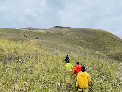
Koubru rises to about 2,560 m on the Kangpokpi–Senapati boundary and is one of the most sacred mountains in Meitei cosmology, home of the deity Koubru. Thousands make the pilgrimage climb each year, particularly in spring, and the summit gives a clean sweep over the Imphal valley on a clear morning.
How to reach
Drive 45–55 km from Imphal via Kangchup or Kangpokpi to a trailhead village, then climb 4–6 hours. A local guide and an early start are essential.
Local tips
- Treat the summit as a shrine: alcohol, meat and loud behaviour are inappropriate.
- Carry all your water; there is no reliable source above the trailhead.
- Descend before dusk; the trail is unlit and easy to lose.
Gallery
On the map
Kangpokpi district, northwest of Imphal · 25.0500°N, 93.8000°E
Mount Koubru
Kangpokpi district, northwest of Imphal
25.0500°N, 93.8000°E
Nearby places
Within an easy detour of Mount Koubru.
Photo: RBN C / Google Maps
WaterfallImphal East
Khunkhu Naga Waterfall / Ariang Waterfall
XRJX+X5H, Khunkhu Naga, Manipur 795002, India
Khunkhu Naga Waterfall / Ariang Waterfall
- Distance from Imphal
- 20 km from Imphal
- Time to allow
- 2 hrs
Entry: Entry details on page
Photo: wijimang chawang / Google Maps
ParkSenapati
Makhan
Makhan, Manipur 795136, India
Senapati district. Reviews mention swimming.
- Distance from Imphal
- 20 km from Imphal
- Time to allow
- 2 hrs
Entry: Entry details on page
Photo: Yaiphaba Soibam / Google Maps
ParkImphal West
Kanto Dam
WVP4+63, Sekmai Nagar, Manipur 795002, India
Kanto Dam
- Distance from Imphal
- 16 km from Imphal
- Time to allow
- 2 hrs
Entry: Entry details on page
 Step-free
MemorialKangpokpi
Kanglatongbi War Memorial
Kanglatongbi, NH-2, Kangpokpi district
The 1944 supply-depot battle, on the highway north
- Distance from Imphal
- 22 km from Imphal
- Time to allow
- 1 hr
Entry: Free entry